Our services include:

We capture locator markings using professional GPS devices and provide data in GIS, CAD,Google or PDF format. Advantages: know where you old or new facilities are and use the information for planning future projects. Import data in your design documents and facilitate decision making
Geo-enabled Maps

We have experience with generating digital and hard copy maps. The most requested mapping solution is our geo-enabled map: allows user to make measurements (distance , area, perimeter) and retrieve LAT/LONG information without printing the map or having to worry about the scale.
GPS data collection

We have over 12 years of GPS and GIS data collection and can help you throughout the project: data setup, workflow design and implementation, data conversion and presentation ( maps). So, if you are looking for capturing above or underground (marked) utilities, or preparing a site map, we are here to help.
Field mapping solutions

Implementing a field computing solution can be challenging. However, our experience can make your implementation a success. If you are considering deploying GIS in the field , or need help deciding the best GPS solution for your needs, please give us a call.
GIS data conversion and analysis
Collect/digitize (from improvement drawings or installed in the field) and analyze data , using GIS technology.
Custom HOA, Event & Site maps
We can assist with creating event maps ( usually for large scale events like sport events and festivals) and site maps ( needed for first responders, in emergency situations). We’ve also created community/HOA maps showing boundaries, parcels and horse trails within the community.
Landscape measurement
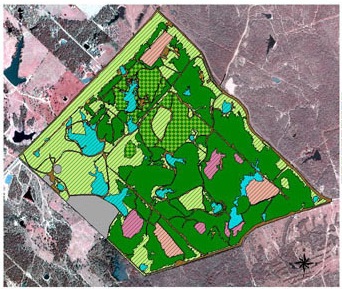
Under current water conditions ( drought) managing the water use becomes an important task. In order to manage water use, landscape companies as well as landscape owners ( residential or commercial) need to know : what type of landscape and how much landscape ( sqft) they need to maintain.
This is where Advanced Mapping comes to help: we can capture the irrigated area and make information like slope and sqft available for the next step: water budget calculation. Maps of landscaped (irrigated) area can be created and they can also contain the layout of the irrigation system.
Note: to deal with current drought conditions, many companies plan on replacing turf with drought -tolerant plants. However, the idea of going back to turf ( mainly for aesthetics reasons) is not abandoned. Capturing the location of sprinkler heads installed for turf irrigation , before converting to drought tolerant plants, will help lower the cost for replanting turf ( no need to redesign irrigation, you just install the sprinkler heads and …you’re done!)
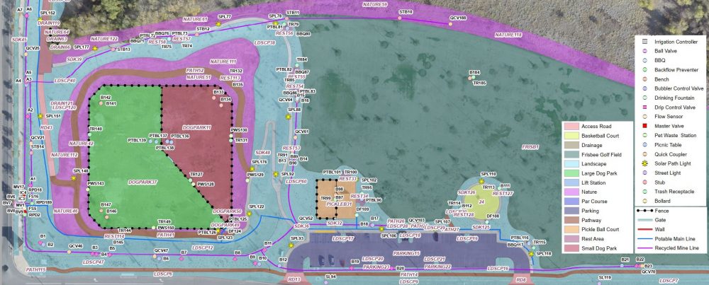
Street Lights Inventory
A complete street lights inventory goes beyond field verification of each street light. A GIS-based inventory is the ultimate inventory: shows actual location , on top of information like wattage and fixture type. All such info can be retrieved from the map…. read more.
Assessment District formation , update and analysis
GIS application also extends to assessment districts. Landscape Maintenance Districts ( LMD),Landscape and Lighting Districts (LLD) and other Special Districts , are all based on a fair distribution of the costs associated with the district maintenance. It all starts with accurately mapping the district assets ( landscaped areas, street lights) using GIS. The GIS data is then used to get cost estimates and prepare beautiful maps.
Drone Services

– We are now able to provide survey mapping services.
GIS training and support
We can provide GIS/GPS/CAD training as well as assist with configuring and deployment of GIS/GPS/CAD projects
Disclaimer
Advanced-Map does not have a licensed Civil Engineer or Surveyor on staff. We map the utility locations as accurately as possible by using advanced GPS technology. The purpose of our project deliverables is meant to give our client a basic overview of the project they are engaging in and to help assess what to expect when designing or performing the preliminary site-work or, help complement client as-builts.